
Weather Alert - Tropical Cyclone Alfred Update (5 March 2025)
With the weather now closing in and the impact of Tropical Cyclone Alfred being fully felt within the next 48 hours we expect that planning and the continuation of deliveries will continue well into tomorrow (Thursday 5 March).
Many members have advised that quite a lot of freight will be staged to the west and or on journey to the north on Friday and fleets will mostly be stood down in Brisbane to recommence operations on Saturday with fleets all having been repositioned out of likely flood affected areas.
In all operations we encourage schedulers to adjust travel times to the conditions and remember bridges such as the Gateway and other bridges will close when sustained wind hits 90kph as has happened on occasions before. With respect to the Gateway Bridge this is a decision taken by Transurban and will only reflect conditions relating to wind speed (remember the Gateway may close on several occasions depending on conditions).
There are many risks to take into account including storm surges, debris on roads and other unexpected damage to roads/bridges. Drivers need to stay vigilant and take time delays into account for their journey.
Key messages:
Pantechs/Fridge/Curtain sides are more impacted by wind. It is recommended commercial operators keep in mind their vehicle capabilities but generally, once wind speeds exceed 50 kilometres per hour, drivers of these higher vehicles should reduce speed and be vigilant especially on empty returns.
Once winds continually exceed 60 km/h driving is strongly discouraged and we recommend these vehicles should park up until safe to move.
More information:
While operators will continually monitor the weather conditions and impact it has on high vehicles there are many factors that impact safe operations when there is high wind - these include the vehicle type, speed and wind direction. Some bridges and sections of road are particularly exposed to winds.
Heavy vehicle operators should always make judgements about whether their specific vehicles are safe to operate in any windy conditions.
There are many reports available on the weather, but we have included the most up to date summary as follows:
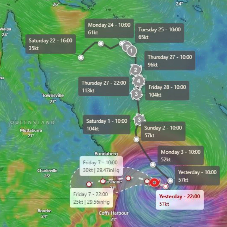
Tropical Cyclone Alfred could hit the Southeast Queensland coast as a category 3 system, with its arrival now moving back to 7am on Friday as it tracks slowly towards the coast.
The Bureau of Meteorology’s technical bulletin suggests there is a possibility the system could intensify before crossing the coast potentially in Brisbane’s south about 7am on Friday, with wind gusts of up to 150km/h expected.
“The possibility of the system reaching a low-end category 3 strength before making landfall cannot be ruled out, but remains a low risk,” the report says.
Alfred is moving west toward the Queensland coast at a rate of 11km/h, with the slow speed giving it the potential to build in intensity.
The heavy rain will begin on Thursday, with the Bureau warning of the likelihood of six-hourly rainfall totals between 60mm and 110mm, and 24-hourly rainfall totals between 80mm and 180mm.
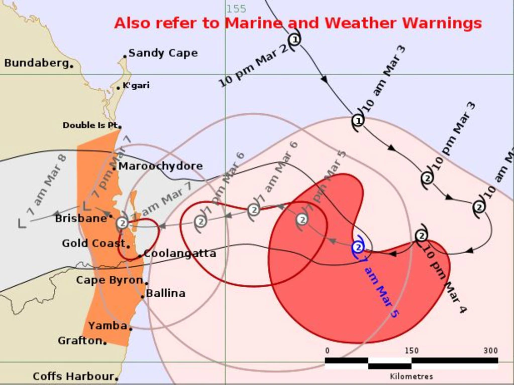
The Bureau of Meteorology said that at 7am on Wednesday Cyclone Alfred was a category 2 system with sustained winds near the centre of 95km/h and wind gusts to 130km/h.
It was estimated to be 425km east of Brisbane and 390km east of the Gold Coast, moving west at 11km/h.
The anticipated 7am landfall time has shifted from 1am as a result of the slow speed of Alfred’s approach, meaning it would miss high tide, which would have increased the flood risk.
Bureau of Meteorology Senior Meteorologist Christie Johnson said as Alfred closes in, heavy rainfall is expected to begin on Thursday, with locally intense rainfall arriving later in the afternoon.
“Several hundred millimetres is possible within six hours which could lead to life threatening flash flooding. We are also expecting damaging winds to develop about the Queensland coast today and then spread further inland tonight and on Thursday,” she said.
The QTA team wishes safe operations, and we cannot stress enough, If it's flooded, Forget it!
Links to Qld Traffic Updates
HEAVY VEHICLE OPERATORS are urged to continuously check QLDTraffic website or call 13 19 40 for real-time updates on road access during these conditions.
South Coast Region, includes Scenic Rim
Darling Downs and South West Region
All Local Councils are putting out regular timely updates on their websites and facebook pages - here